The historical setting
The Burke and Wills expedition, originally called the Victorian Exploring Expedition, was an exploration expedition organised by the Royal Society of Victoria (RSV) in Australia in 1860–61. The exploration party initially consisted of nineteen men led by Robert O'Hara Burke, with William John Wills being a deputy commander. Its objective was the crossing of Australia from Melbourne in the south to the Gulf of Carpentaria in the north, a distance of around 3,250 kilometres (approximately 2,000 miles). At that time most of the inland of Australia had not been explored by non-Indigenous people and was largely unknown to European settlers. The expedition left Melbourne in winter. Very bad weather, poor roads and broken-down horse wagons meant they made slow progress at first. After dividing the party at Menindee on the Darling River, Burke made good progress, reaching Cooper Creek at the beginning of summer.
Departure from Melbourne
The Burke and Wills expedition set off from Royal Park at about 4pm on 20 August 1860, watched by around 15,000 spectators. The nineteen men of the expedition included six Irishmen, five Englishmen, three Germans, an American, and four camel drivers from the Indian subcontinent. They took twenty-three horses, six wagons and twenty-six camels. The expedition took a large amount of equipment, including enough food to last two years, a cedar-topped oak camp table with two chairs, pocket charcoal water filters, rifles, revolvers, rockets, flags and a Chinese gong; the equipment all together weighed as much as twenty tonnes.
Committee member Captain Francis Cadell had offered to transport the equipment from Adelaide up the Murray River to the junction with the Darling River to be collected on the way. However, Burke declined his offer, possibly because Cadell had opposed Burke's appointment as leader of the expedition. Instead, all of the supplies were loaded onto six wagons. One wagon broke down before it had even left Royal Park and by midnight of the first day the expedition had reached only Essendon, on the edge of Melbourne. There, two more wagons broke down.
Return journey to Cooper Creek
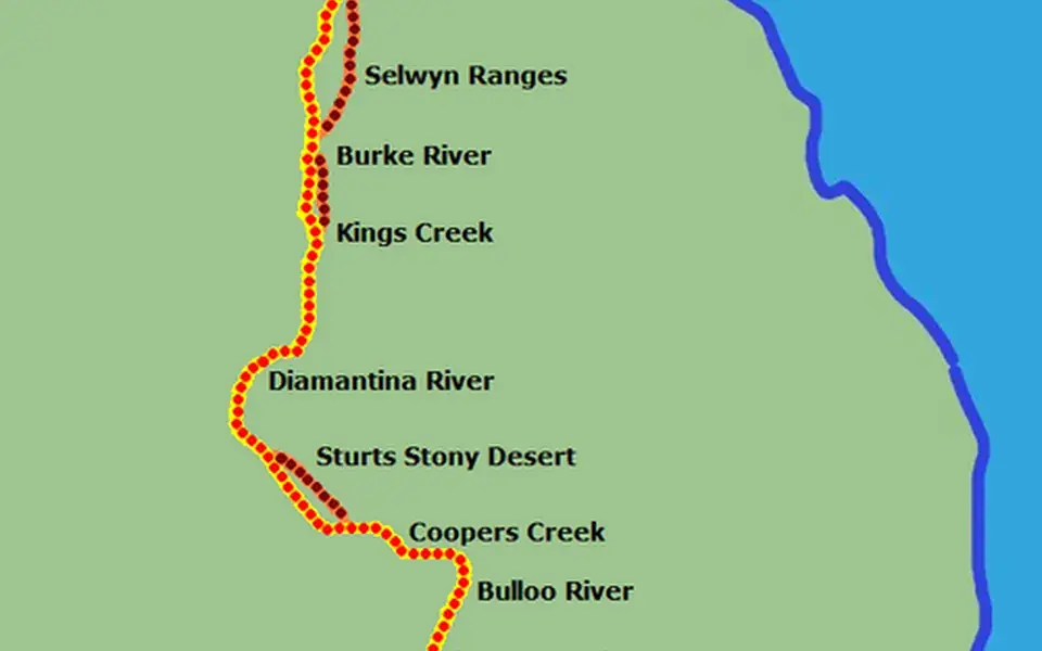
To extend their food supply, Burke's party ate portulaca, a flowering plant. Gray also caught an 11 lb (5.0 kg) python (probably Aspidites melanocephalus, a black-headed python), which they ate. Both Burke and Gray immediately came down with dysentery. Gray was ill, but Burke thought he was "gammoning" (pretending). On 25 March on the Burke River (just south of what is now the town of Boulia), Gray was caught stealing skilligolee (a type of watery porridge) and Burke beat him. By 8 April, Gray could not walk; he died on 17 April of dysentery at a place they called Polygonum Swamp. The location of his death is unknown, although it is generally believed to be Lake Massacre in South Australia.
While the possibility that Burke killed Gray has been discounted, the severity of the beating Burke gave has been widely debated. The three surviving men stopped for a day to bury Gray, and to recover their strength – they were by this stage very weak from hunger and exhaustion. They finally reached Cooper Creek on 21 April, only to find that the depot in charge of Brahe had been abandoned several hours earlier.
Burke, Wills and King at Cooper Creek
Burke, Wills and King arrived at Camp 65 in the evening of Sunday, 21 April 1861, finding the Cooper Creek depot deserted after Brahe's group had left earlier that day. They found the "Dig Tree" and dug up the cache of supplies together with Brahe's letter explaining that the party had given up waiting and left. Burke's party had missed them by only nine hours. The three men and two remaining camels were exhausted; they had no hope of catching up to Brahe's party. Burke's party rested at Camp 65 for two days, living off the supplies left in the cache.
Wills and King wanted to follow their outward track back to Menindee, but Burke overruled them and decided to attempt to reach the furthest outpost of pastoral settlement in South Australia, a cattle station near Mount Hopeless. This would mean travelling southwest through the desert for 240 kilometres (150 mi). They wrote a letter explaining their intentions and reburied it in the cache under the marked tree in case a rescue party visited the area. Unfortunately, they did not change the mark on the tree or alter the date.